
The Laguna Niguel Commute: Toll Roads, the I-5, and Choosing a Neighborhood by Drive Time
How much does commute vary by neighborhood within Laguna Niguel?
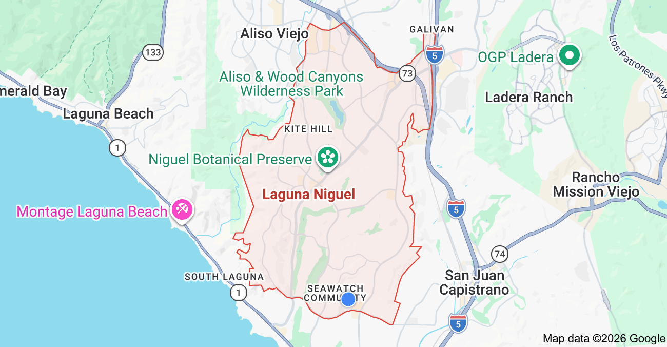
Quite a bit. Where you land inside Laguna Niguel changes which freeway is closest, and the SR-73 toll road along the city's northern and western edge serves Irvine, Newport, and the airport, while the I-5 along the eastern edge serves everyone heading inland and north. Drive time to Irvine, John Wayne Airport, and the coast can swing by fifteen to twenty minutes depending on your street, so it is worth mapping your real commute before you choose a neighborhood.
Most buyers narrow a Laguna Niguel search by price first and views second, and almost no one maps the commute until after they have fallen for a house. Then they make the actual drive to work on a Tuesday morning and discover the home they loved adds twenty minutes each way to a daily trip they will make for years. In a city where most people drive out of town to work, that is not a small detail. It is one of the biggest quality-of-life decisions hiding inside the purchase, and it is invisible on a listing.
Laguna Niguel is, by its own description, a bedroom community. Most residents commute to job centers in central and north Orange County, places like Irvine and Newport Beach, and how easy that is depends a great deal on which part of the city you call home. This guide lays out how the toll road and the freeway serve different parts of Laguna Niguel, how drive time to the places that matter shifts by neighborhood, and how to weigh all of it against price and views while you are still narrowing the search. For the wider picture of the city's neighborhoods and lifestyle, start with my local guide to living in Laguna Niguel.
Laguna Niguel is a commuter's city
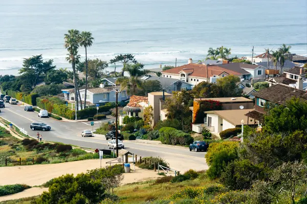
It helps to picture the shape of the place. Laguna Niguel sits on hilly terrain, which means its streets do not run in a tidy grid, and that geography matters more than buyers expect. The spine of the city is Crown Valley Parkway, which cuts across Laguna Niguel from southwest to northeast and links the coast at Pacific Coast Highway in Dana Point all the way up to the I-5 in Mission Viejo. Almost everyone's daily drive touches Crown Valley or one of the other major arterials, Alicia Parkway, La Paz Road, Golden Lantern, Moulton Parkway, at some point.
Because this is a drive-first city, the two ways out of town do most of the work in shaping a commute, and they sit on opposite edges of Laguna Niguel. Understanding which one you will lean on, and how close you are to it, is the whole game.
The two roads out of town
The 73 toll road
The SR-73, formally the San Joaquin Hills Transportation Corridor, runs along the northern and western edge of Laguna Niguel. It is a toll road managed by the Transportation Corridor Agencies, and it exists as a faster, less congested alternative to the perpetually crowded I-405. For a Laguna Niguel commuter, the 73 is the natural route toward Irvine, Newport Beach, and John Wayne Airport. The catch is in the name. It is tolled, the tolling is all-electronic now, so you either carry a FasTrak transponder or get billed through your license plate, and the cost of a daily round trip adds up over a month and a year. Laguna Niguel's most direct connection to the 73 is near Greenfield Drive by Crown Valley Parkway, so how convenient the toll road is depends on which side of the city you live on.
The I-5
The I-5 forms the eastern border of Laguna Niguel, with two interchanges serving the city, at Crown Valley Parkway and at Avery Parkway. It is the free route, and it is the one you take heading inland or north toward most of Orange County and beyond. It is also subject to the standard Orange County morning crawl, so free does not always mean fast. For buyers on the eastern and northeastern side of the city, the I-5 on-ramps are minutes away, which is a genuine daily advantage.
How drive time changes by where you land
This is where the twenty-minute swing lives. Homes on the eastern and northeastern side of Laguna Niguel, nearer the Crown Valley and Avery interchanges, have the quickest access to the I-5 and to the Metrolink station, which suits a commuter heading inland or north. Homes toward the northern and western side sit closer to the 73 connection, which favors anyone driving to Irvine, Newport, or the airport on the toll road. And homes on the southern, coast-facing side of the city trade freeway convenience for beach proximity, with a lovely short hop to Pacific Coast Highway but a longer run to reach either the 73 or the I-5.
None of these is better in the abstract. The point is that a single Laguna Niguel address quietly commits you to a particular commute pattern, and two homes you might consider in the same week can sit on opposite sides of that divide. The buyer who knows their real destinations can use this to their advantage rather than discovering it the hard way.
Drive times to the places that matter
Treat these as directional, since traffic and time of day move them around, but they give a useful sense of the geography. Irvine, the largest nearby job and shopping hub, is generally a twenty to thirty minute drive depending on your starting point and whether you take the 73 or the freeways. John Wayne Airport is a similar twenty to thirty minutes, and the 73 is the road that takes you there most directly. The coast is the easy one, with Salt Creek and the Dana Point beaches usually ten to fifteen minutes away down Crown Valley Parkway to the highway. The pattern is the story. The beach is close from almost anywhere in the city, while the job centers reward living on the side of town that faces your particular freeway.
The car-free option people forget
Laguna Niguel also has something a lot of South Orange County cities do not, a commuter rail station of its own. The Laguna Niguel/Mission Viejo Metrolink station sits at Forbes Road on the eastern side of the city near the I-5, with free parking, and it is served by both the Orange County Line and the Inland Empire to Orange County Line. The ride to Irvine runs only about ten to fifteen minutes, and the line continues toward Santa Ana, Anaheim, and Los Angeles in one direction and San Juan Capistrano, Oceanside, and San Diego in the other. For a buyer whose work sits near a station, especially in Irvine or downtown LA, a home on the station side of the city can turn a stressful drive into a train ride with a coffee, and that is worth factoring into where you look.
How to weight commute against price and views
Here is the practical way to fold all of this into a search. Start by naming your real, regular destinations, the office, the airport for frequent travelers, the route you drive most days, and be honest about how often you make each trip. Then test-drive the commute from a couple of candidate neighborhoods at the actual hour you would travel, not at noon on a Sunday when everything is easy. If your route is the 73, put the toll into your monthly budget so the comparison between homes is honest. And when you weigh a cheaper home or a better view against a longer commute, do the simple math, because twenty minutes each way is more than three hours a week and well over a hundred hours a year of your life. Sometimes the view is worth it. Sometimes the closer, plainer house is the one you will be glad you chose every single morning. Knowing your own answer before you fall in love with an address is the whole point.
Quick Facts
| Topic | What buyers should know |
|---|---|
| The two routes out | The SR-73 toll road runs the northern and western edge toward Irvine, Newport, and the airport. The I-5 runs the eastern edge with interchanges at Crown Valley and Avery |
| Main spine | Crown Valley Parkway crosses the city southwest to northeast, linking Pacific Coast Highway in Dana Point to the I-5 in Mission Viejo |
| The 73 toll | All-electronic tolling, paid by FasTrak transponder or license plate. A daily round trip is a real recurring cost worth budgeting |
| East and northeast side | Quickest access to the I-5 and the Metrolink station. Suits inland and northbound commuters |
| North and west side | Closest to the 73 connection near Greenfield Drive. Suits Irvine, Newport, and airport commuters |
| South and coastal side | Best beach access, a short run to Pacific Coast Highway, but a longer drive to either freeway |
| Drive times | Roughly 20 to 30 minutes to Irvine and to John Wayne Airport, and about 10 to 15 minutes to the coast. Approximate and traffic-dependent |
| Rail option | Laguna Niguel/Mission Viejo Metrolink station at Forbes Road, free parking, about 10 to 15 minutes to Irvine, with service toward LA and San Diego |
Frequently Asked Questions
What freeways and toll roads serve Laguna Niguel?
Laguna Niguel is served by the I-5 along its eastern border, with interchanges at Crown Valley Parkway and Avery Parkway, and by the SR-73 toll road, the San Joaquin Hills Transportation Corridor, along its northern and western edge. Pacific Coast Highway runs just outside the southern boundary for coastal access. Crown Valley Parkway is the main thoroughfare connecting the coast to the freeway.
Is the 73 toll road worth it for a Laguna Niguel commute?
For many commuters heading to Irvine, Newport Beach, or John Wayne Airport, the 73 saves real time over the often-congested I-405, which is its whole purpose. The trade-off is cost, since it is all-electronic tolling paid by FasTrak or license plate and a daily round trip adds up. Whether it is worth it depends on your route, how much you value the time saved, and how comfortably the toll fits your monthly budget.
Does Laguna Niguel have a train station?
Yes. The Laguna Niguel/Mission Viejo Metrolink station sits at Forbes Road on the eastern side of the city near the I-5, with free parking. It is served by the Orange County Line and the Inland Empire to Orange County Line, with a ride to Irvine of about ten to fifteen minutes and continuing service toward Santa Ana, Los Angeles, San Juan Capistrano, and San Diego. For commuters whose work is near a station, it can be a genuine car-free option.
Which side of Laguna Niguel is best for commuters?
It depends entirely on where you are going. The eastern and northeastern side offers the quickest access to the I-5 and the train station, which suits inland and northbound commuters. The northern and western side is closest to the 73 connection, which favors Irvine, Newport, and airport commuters. The coastal side is farther from both freeways but closest to the beach. The best side is the one that points toward your regular destinations.
A Final Word from Susan Chase
Commute is one of the most underrated factors in a Laguna Niguel home search, and one of the easiest to get right if you think about it before you fall for an address rather than after. The city is small, but its hills and its two very different roads out of town mean the daily drive can vary by twenty minutes from one neighborhood to the next. That difference compounds into hours every week, so it deserves a place in the decision right alongside price and views.
If you are weighing neighborhoods in Laguna Niguel and want help matching the right side of the city to your actual commute, your budget, and the toll-versus-time math, reach out. I will help you test the drives that matter and find the home that feels right not just on the tour but on a Tuesday morning. You can reach me at the contact below whenever you are ready to talk.

Susan Chase Group | Compass
Dana Point, California
949-370-6950
susan.chase@compass.com
livingincoastaloc.com
🙋🏻♀️ I'm Susan Chase, your South Orange County Realtor, advisor and guide, helping buyers, sellers, and relocations right-size and find a coastal home and lifestyle they'll love. ❤️
Living in Coastal OC is the editorial home of Susan Chase and the Susan Chase Group at Compass, serving buyers, sellers, and relocations across Laguna Beach, Dana Point, Laguna Niguel, San Clemente, and San Juan Capistrano. For private consultations, neighborhood tours, or relocation guidance, contact us at livingincoastaloc.com.
Sources & Data Verification. Laguna Niguel's road network, including the I-5 along the eastern border with interchanges at Crown Valley Parkway and Avery Parkway, the SR-73 San Joaquin Hills Transportation Corridor toll road along the northern and western edge with its local connection near Greenfield Drive, Crown Valley Parkway as the main thoroughfare linking Pacific Coast Highway in Dana Point to the I-5 in Mission Viejo, and the city's hilly, non-grid street pattern: City of Laguna Niguel circulation and general plan references and public geographic references. The SR-73 as a toll alternative to the I-405 managed by the Transportation Corridor Agencies, using all-electronic tolling via FasTrak or license-plate billing: Transportation Corridor Agencies and California highway references. Laguna Niguel as a bedroom community whose residents largely commute to job centers such as Irvine and Newport Beach: public city profile references. The Laguna Niguel/Mission Viejo Metrolink station at 28200 Forbes Road, served by the Orange County Line and Inland Empire to Orange County Line with free parking and connecting service toward Irvine, Santa Ana, Los Angeles, San Juan Capistrano, Oceanside, and San Diego: Metrolink references. Drive times to Irvine, John Wayne Airport, and the coast are approximate and vary significantly by starting point, route, time of day, and traffic, and are presented as directional estimates rather than guaranteed figures. Toll amounts, schedules, and traffic conditions change over time. Confirm current toll costs with the Transportation Corridor Agencies, current rail schedules with Metrolink, and test your specific commute in person before making a purchase decision.
Categories
- All Blogs (152)
- 2026 Harbor & Coast Reports (2)
- Coastal OC Lifestyle (14)
- Guides (11)
- Into the Weekend with Susan (1)
- Living in Dana Point (20)
- Living in Laguna Beach (20)
- Living in Laguna Niguel (19)
- Living in San Clemente (18)
- Living in San Juan Capistrano (17)
- Micro-Market Deep Dives (5)
- Relocation (3)
- Right Sizing Strategy (6)
- Strategic Market Intelligence (17)
Recent Posts




REVIEWS